

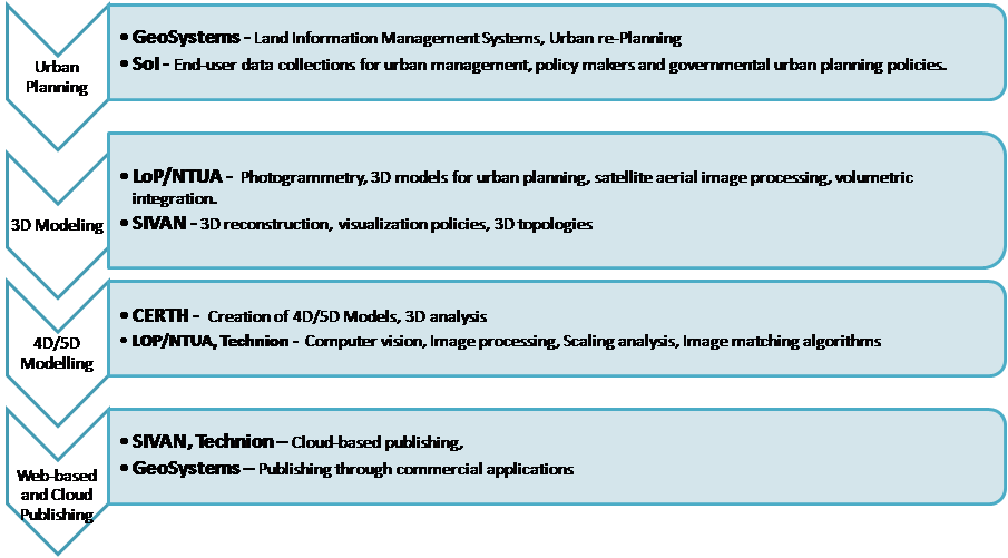
The project consortium has been carefully selected to adequately address the needs for research and innovation towards the scientific and technological objectives of the proposal and also to ensure a smooth and untroubled transformation of the research results into real products, encompassing market wise experience and good knowledge of stakeholders' needs. The main research and technological components of the project are depicted in the following figure along with the key partner responsible to carry out this research activity. In particular, the research includes:
- Urban planning: It includes land information management systems, urban re-planning, policy making and governmental policy actions. GeoSystems as specialized land information management system company and SoI as end-user will cover this activity.
- 3D Modelling: It includes research on 3D models construction for urban planning, photogrammetry, volumetric integration models and image registration, 3D topologies and visualization actions. LoP/NTUA as the leading photogrammetric laboratory in Greece and SIVAN as specialized Israeli company in 3D topologies are involved in this activity.
- 4D/5D modeling: This research activity includes creation of 4D and 5D models, 3D image analysis tools, computer vision algorithms, image matching and scaling analysis. LoP/NTUA is involved in this activity since the lab includes a specialized team of computer vision expertise. In addition, CERTH-ITI-VCL covers the creation of 4D and 5D models as the leading Greek institute in this area.
- Web-based and Cloud computing: This activity covers web-based and cloud computing services so as to promote the actions of 5D models. SIVAN and GeoSystems are involved in this activity.
More specifically, the project consortium is comprised by the following partners:
- GEOSYSTEMS HELLAS S.A. (Project Coordinator - Greek side)
GEOSYSTEMS HELLAS S.A. (GSH) was established in November 2009 as GEOSYSTEMS EU GROUP Member (www.geosystems-group.eu) constituting a leading provider of geospatial solutions as well as technologies designed for geographical data capturing, processing, analysing and presenting. The success of the company is based on the qualified staff with experience of at least 15 years working in the same market, comprised from earth scientists, software engineers and information technology engineers. GSH puts its effort into promotion of innovative geospatial methods and technologies among users from different disciplines (project implementation, technical support, consultancy, workshops) in the field of remote sensing, photogrammetry and Geographical Information Systems, conducting research and development projects, while also acting commercially as Intergraph solutions authorized reseller and as consultant in Greece and Cyprus on subjects of Geodetic and Environmental Monitoring (as partner of Metrica SA, www.metrica.gr). GEOSYSTEMS HELLAS S.A. is a legal e-GEOS representative authorized in Greece and Cyprus to handle all e-GEOS satellite imagery products.
- The Laboratory of Photogrammetry of the National Technical University of Athens
 LoP/NTUA expertise is on the field of photogrammetry and computer vision research, participating in numerous European Union and National funded projects. Characteristics examples include a) the on-going FP7 research project 4D-CH WORD EU, dealing with computer vision and photogrammetric applications for 4D content reconstruction of cultural heritage objects being captured on the wild over the Web, b) the on-going ITN-DCH FP7 research project which applies advanced tools in content-based search, 3D modeling and image analysis for cultural heritage applications, c) the on-going FP7 research project of ROBINSPECT dealing with the introduction of real time and accurate 3D measurements from a set of images/video as regards tunnel inspection and maintenance (the application includes the maintenance of highway, Metro and Railway Tunnel, such as the London Tube, Eurotunnel and Egnatia highway of 670Kms and 76 tunnels), e) the on-going FP7 European research eVACUATE with the purpose of developing real time 3D measurements from RGB and hyperspectral sensors in order to track, analyze and detect crowd behaviors in case of emergency (the applications include evacuation of airports, metro stations, ships cruises and soccer stadiums), f) the on-going National research project of JASON with the purpose of surveying humans and ships from stereo images for sea-borders monitoring. Apart from the above mentioned research the LoP/NTUA group have been participated in the 3D reconstruction of several cultural heritage monuments, such as several items of the National Archeological and Acropolis Museum, large scale 3D reconstructions of UNESCO monuments (Church of the Holy Sepulcher, the Delos archaeological site, Zalogo Monument, Nia Moni Church).
- Laboratory of Computing and Cognitive Vision, Information Technologies Institute (ITI)
![]()
The Laboratory of Computing and Cognitive Vision is very active in problems of cognitive vision and human visual perception, as well as on vision for 3D object and face recognition, having in mind robotics and security applications, as well as database search and retrieval. We have extensive experience in photometric stereo, that allows the 3D reconstruction of an object using several images captured under various illumination directions.
- Sivan Desing LTD. (Project Coordinator - Israeli side)
![]() Sivan Design was incorporated in 1996 and rapidly became a global provider of customized enterprise level geospatial solutions integrating ERP (Enterprise Resource Planning) capabilities with GIS (Geographical Information System), a developer of 3D GIS applications, and a developer of Civil Engineering CAD and 3D Simulation software.
Sivan Design was incorporated in 1996 and rapidly became a global provider of customized enterprise level geospatial solutions integrating ERP (Enterprise Resource Planning) capabilities with GIS (Geographical Information System), a developer of 3D GIS applications, and a developer of Civil Engineering CAD and 3D Simulation software.
The company is highly experienced in the development and implementation of GIS software solutions for land administration, management of roads, highways, underground infrastructure, contracts, and maintenance.
The company has expertise in: (a) Development, implementation and maintenance of turnkey GIS land administration projects, roads information systems, and water infrastructure projects helping clients achieve more efficient processes tied to land and properties, roads and railways, and underground infrastructures management, (b) Development of 3D GIS in the cloud applications that can be accessed by web browsers, iPad and Smartphones Apps, and mobile devices, (c) Development of state-of-the-art civil engineering design software CivilCAD, and Civil Simulate – a software tool for creating hyper realistic, drive-through 3D simulation and visualizations of roads and highways.
- Faculty of Civil and Environmental Engineering Technion - Israel Institute of Technology
![]() The Technion – Israel Institute of Technology is one the leading research institutions worldwide, having a strong National and International profile for research and technology. On December 19, 2011, a bid by a consortium of Cornell University and Technion won a competition to establish a new high-tier applied science and engineering institution in New York City. The competition was established by New York City Mayor Michael Bloomberg in order to increase entrepreneurship and job growth in the city’s technology sector. The winning bid consisted of a 2.1 million square feet state-of-the-art tech campus being built on Roosevelt Island, which will have its first phase completed by 2017, with a temporary off-site campus opening in 2012.
The Technion – Israel Institute of Technology is one the leading research institutions worldwide, having a strong National and International profile for research and technology. On December 19, 2011, a bid by a consortium of Cornell University and Technion won a competition to establish a new high-tier applied science and engineering institution in New York City. The competition was established by New York City Mayor Michael Bloomberg in order to increase entrepreneurship and job growth in the city’s technology sector. The winning bid consisted of a 2.1 million square feet state-of-the-art tech campus being built on Roosevelt Island, which will have its first phase completed by 2017, with a temporary off-site campus opening in 2012.
The Technion – Israel Institute of Technology is a public research university in Haifa, Israel. Founded in 1912, Technion is the oldest university in Israel. The university offers degrees in science and engineering, and related fields such as architecture, medicine, industrial management and education. It has 18 academic departments and some 50 research centers. Since its founding, it has awarded over 95,000 degrees and its graduates are cited to have provided the skills and education behind the creation and protection of the State of Israel.
- Survey of Israel
 Survey of Israel is the government agency for Mapping, Geodesy, Cadastre and Geoinformatics. The Survey is responsible for the national infrastructure in these areas as well as for a number of official functions. In many countries the responsibility for these various areas is shared by several agencies. There is much to be said for centralized responsibility, because of saving professional human resources and the potential of increased efficiency and improved level of services to the public. There is coordination of activities and of investments and the potential for making a concentrated effort in cases of a defined task of national importance. It is essential to develop professional policy in the various areas of the responsibility of the Survey, including the licensing of surveyors and the supervision of surveys. In the field of geodesy, the Survey operates as the National Geodetic Institute, adopting the reference ellipsoid, developing and maintaining the geodetic control network, defining the national datum, both horizontal and vertical and establishing an appropriate projection with accompanying mapping equations and transformations, for applications in mapping, cadastre and geoinformatics. The Survey represents the country in international projects. Its Chief Scientist leads research, as well as geodetic surveys and temporarily acts as Registrar of Surveyors.